
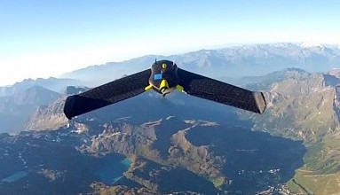
eBees Map the Matterhorn
on
At the recent Drone and Aerial Robots Conference (DARC) held in
Three drones, developed by a company called senseFly were hand-launched from points on the mountain (including the summit) and spent a total of six hours (from 11 launches) flying around the mountain following pre-programmed flight patterns. The resulting 2000 hi-def images were then processed by the company Pix4D to produce the most detailed 3D representation of the mountain so far. Despite the fact that the drones were not using traditional surveying methods or tools, accuracy of the resulting representation is claimed to be within 10 cm. The company’s software eMotion 2 provided all the ground control for the flights, automatically generating flight paths for the multiple drones and returning them to preset locations.
Both senseFly and Pix4D are spin-off companies working closely with the Ecole Polytechnique Fédérale de Lausanne (EPFL) in
Discussion (0 comments)