
Lidar, Arduino, Raspberry Pi, Laser, ToF and more
June 13, 2019
on
on
 The word LiDAR, with "Li" for "Light", indicates an optoelectronic echolocation device. From which we can deduce that instead of emitting radio frequency pulses, a lidar emits a pulsed laser beam, the echoes of which permit us to determine the distance of any obstacle that reflects light. Stemming from the word radar (RAdio Detection And Ranging) this word has existed for some fifty years, but it has never been heard so often as in recent times. The main reason is that until now there has never been talk of self-driving cars, or of mobile robots capable of moving around an unknown environment and of mapping it in real time.
The second reason is the availability of cheap lidars, within the reach of anyone, yet with interesting specifications. Little by little, the possibility of using open-source software to control a lidar has come beyond the experimental stage.
Lidar, Arduino, Raspberry Pi, Laser, ToF and more
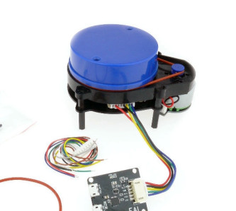
Even without being a specialist in the techniques used, the combination of a lidar, whether fixed, oscillating or rotating, with an Arduino (or a Raspberry Pi) will take you far in distance measuring or digitizing a space by echolocation. At the top end of the range of lidar’s possibilities, it can offer a precision of a few centimetres when mapping a large hilly surface. The range can extend to hundreds of kilometres for spatial systems. Among possible applications are 3D scanning of environments (for example architecture, cities, caves, archeology), real time telemetry for piloting ground-based or flying vehicles, speed control of vehicles (flash!) precision topography of earth or other bodies in the solar system, or even in forestry to observe the canopy.Triangulation, phase detection, time of flight (ToF)
However, before attempting obstacle detection or distance measuring and mapping, we should familiarize ourselves with the notion of the various measurements, such as triangulation, phase measurement of the reflected wave, or even measurement of the ‘time of flight’ of the light. We should at least know how to use the sensors and software used for solving these problems.And what better way to inform ourselves than several (short) well made videos?
In the first, a fixed lidar, mounted on an oscillating arm controlled by an Arduino, gives some amazing results.
In this sequence, a fixed TOF lidar measures distance in real time:
Here, a rotating YDLiDAR X4 lidar is used with the Google programme Cartographer for a spectacular mapping experience.
On his YouTube channel, the same author offers other applications of mapping with ROS, YDLIDAR X4 and a Raspberry Pi 3 B+.
The Elektor Store offers several new products enabling you to carry out such hand-on experiments (see below).
Read full article
Hide full article
Discussion (0 comments)