
MIT Develops Wearable Real Time Mapping Device
September 26, 2012
on
on
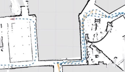
A sensor array that can be strapped to the chest builds a map in real time as the user moves through the environment.
The team of MIT’s Computer Science and Artificial Intelligence Laboratory built the wearable mapping system with emergency personnel in mind. First responders who enter unknown territory automatically create a map of the environment they’re exploring. The data can be transmitted wirelessly making the map immediately available to an offsite commander.
The technique of building a map while at the same time determining one’s position on it has been extensively researched in robotics. Simultaneous Localization And Mapping (SLAM) is considered a prerequisite for bots to become truly autonomous.
The team’s innovation is making a SLAM system for human users. Humans move more erratically than robots making it more difficult to get accurate readings from the sensors.
The device is worn like a backpack. On the front is a plastic board with sensors screwed onto it. On the back is a computer to process the data. The sensors include a laser rangefinder which measures the distance to an object by sending out a laser beam and measuring the time it takes for the light to return. On a level platform like a rolling robot a rangefinder can be very accurate, but a person walking sways back and forth. Therefore the team added gyroscopes to provide additional data about the orientation of the rangefinder’s at the time of its reading.
A Microsoft Kinect camera takes snapshots of the environment at regular intervals. Software interprets the depth and color data contained in the images to add to the map.
Besides humans not being a particularly stable platform, the MIT team also had to take into account people easily move between the different floors of a building. SLAM systems built for robots generally don’t bother to much with the problem of height because most of today’s robots can’t use stairs or elevators. To avoid overwriting the map of one floor with the data of another, the team added accelerometers and a barometer to determine changes in altitude.
The team wants to improve the system by making it smaller and adding the possibility for users to mark points of interest on the map using spoken or text commands.
Source: MIT
Read full article
Hide full article
Discussion (0 comments)