
Zero discharge monitoring
Zero discharge is one major step towards making an industrial plant non-polluting. Here we use LoRaWAN to monitor a plant's drains.
Zero Discharge LoRa water level sensor
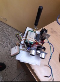
Prototype : Low power Sender unit
Trunk drain monitoring / Zero discharge : Zero discharge is one major step towards making a plant non-polluting. It says that a plant / industry can intake water but it should not discharge any water or liquid from it's periphery. First of all it should not have any drain coming out of it and if at all there is a drain coming out of it - it should be running dry.
... ... ...
Project:Zero discharge Monitoring
A few thousand acres of land with 3 trunk drains and more than half-dozen exit points - maintaining a zero discharge is one of the top priority to comply with the pollution control board of MP (MPPCB). But all the drains are located fur flung from the main control station, some are at least 3 kms away.
Therefore, which one is overflowing and which one is underflowing is very difficult to find out unless some operator / supervisor makes a round of the 10 km periphery to identify each one is the culprit.
Of course if nobody notices, the PCB will notice it and the next day a memo will arrive in the inbox !
Plant manager is on the toes now. Of course the pumps are there to pump it back to the clarifloculator for filtration but who knows when these pumps fail or stops working.
“We need a reliable drain monitoring system for all the exit points and that too right at the 24*7 control desk” , The plant manager declares with utmost impunity.
“In case the level goes high and the pumps fail to serve, we will lower the sluice gate in the first so that the drain does not flow out”, He added further.
“Our OFC network cannot reach so far away”, The IT man chips in.
This is the point when I suggested the LoRaWan for all these 6 exit points. The ultrasonic prob will pick up the level data from the opening of these drains. It will relay back to the central LoRa unit, and the central LoRa unit will plot them on a single file or on a Google Map and the project is born !
... ... ....
Cost: The whole setup comes under $100 when cheap ATMEGA328P - PU , UBlox GPS receiver , HC-SR04 ultrasonic probe & Dorjee / Hope spread spectrum transceiver module along with a 10 watt poly crystalline solar panel is used..
The whole set up is placed under the shade of a 10 watt solar panel. The 12 volt output goes to a 5.5AH ,6 volt battery for charging and powering the module which runs on 3.3 volt supply. The ultrasonic HC-SR04 needs 5 volt supply to work therefore, the module has an extra 5volt regulated supply too.
Operation philosophy: IC LM7805 & LM-1117 are used for making the 3.3 volt & 5 volt supply header. The Ultrasonic probe directs towards the channel flow and measures the level of water.
It then sends data on spread spectrum which reaches the control room 2 to 3 kms away. Small 3 Dbi to 5 Dbi antenna is sufficient to upload and receive data. Some Line-Of-Sights are obstructed by branches of big trees but for LoRa signal it did not pose any problem.
The major trick lies how you deploy multiple instances of softwareserial library in Arduino sketch. Both the GPS receiver and the Spread spectrum radios runs on makeshift UART port of Arduino. To ensure that one does not fowl with the others, I've ensured port.listen() & port.end() is deployed at the right moment which makes the sonic readings steady & stable.
The signal is collected on a Linux laptop having an USB LoRa connected. The software used gtkterm ,minicom, picoterm or any other serial communication tool - or the windows serial communication tool. The channel and frequency used on all the LoRa modules are same. Therefore, the laptop gets signals from all the different locations having different locations numbers and GPS locations.
Each sender is programmed to send the following data - latitude, longitude, time, level & location-number. The same appears on the gtkterm terminal like this. Also we have developed a hand held device to collect data on the same. Here's a view on the laptop.
24.088690,82.648170,12:22:20, 8.0,Loc-2
24.088690,82.648178,12:22:41, 8.0,Loc-2
24.088720,82.648178,12:23:02,194.0,Loc-1
24.088751,82.648132,12:23:23,193.0,Loc-1
The drain level can be identified from the location number or from the lat & lon GPS location. We've also developed an app on Processing which will clearly mark the location on a Google map but only one at a time.
Power consumption: To save power we have used lopower.h header file which can insert a maximum delay of 8 seconds during which the ADC_OFF, BOD_OFF is set. The delay timer used for 2*8 seconds and the total delay we get is 21 seconds. During this time the sender module on a 6 volt 5.5 AH lead-acid battery takes about 90 milli ampere current 19 seconds and 205 milli ampere current for 2 seconds during which it transmits. Therefore on a 5.5 AH battery it works for 55 hours non stop. However, the 10 Watt solar panel helps the battery to recharge during the day time.
Schematic - Sender (low Power):
4*16 LCD - handheld receiver: Runs on a single Li-Ion cell
Receiver: The USB unit - directly connects to the Laptop
Hand held receiver - 4*16 LCD
Display: On LCD display or Google Map on processing it will show only one at a time, while on USB LoRa on the Laptop you can see multiple lines, each representing different or same Locations. To reduce battery consumption of the hand held device the back light power supply may be kept off.
Arduino_sketches:arduino_sketches
S. Bera / Vindhyanagar
Build This Project
Bring this design to life with the Elektor PCB Service, powered by Eurocircuits. Upload the project files and order professionally manufactured PCBs or assembled boards through a proven European production platform.
Supporting KiCad, Eagle, Gerber, and ODB++ formats, the service is suitable for everything from prototypes and validation builds to series production and volume manufacturing.
Made in Europe. Fast. Reliable. Professional.
Discussion (2 comments)